
Metro Detroit will move from bitter cold to potentially disruptive snowfall this weekend, creating significant travel concerns during one of the busiest travel periods of the year. A developing winter storm is expected to bring widespread accumulating snow Saturday afternoon through early Sunday, following a sharp drop in temperatures Friday morning.
The 4Warn Weather team is declaring a 4Warn Weather Alert for both Saturday and Sunday.
Thanksgiving Night: Cold, breezy, and some snow in the Thumb
Thanksgiving night will remain cold and breezy across Southeast Michigan as many people head home from holiday gatherings. Temperatures will fall into the mid-20s, but wind gusts between 15 and 25 mph will make it feel much colder. Wind chills will dip into the teens, and drivers should expect a noticeable chill when walking to and from their vehicles. While most of Metro Detroit will stay dry, the Thumb — including Sandusky, Bad Axe, and other parts of Huron and Sanilac counties — will continue to see occasional lake-effect snow showers. These bands may briefly reduce visibility and create slick spots on rural roads and open stretches of M-25 and M-19. For most of the region, conditions will remain dry but brisk as people return from Thanksgiving dinners or travel to late-night shopping events.
Friday: Bitter cold and early snow in the Thumb
Before the snow arrives for the weekend, the region faces a blast of cold air Friday morning. Temperatures will start in the lower- to mid-20s, but gusty west-northwest winds will make it feel much colder. Wind chills will dip into the single digits and teens for morning shoppers. Despite the frigid start, Black Friday will be mostly dry across Metro Detroit, aside from the chance for scattered flurries.
Saturday: Snow arrives and travel impacts increase
The winter storm begins to move into the region Saturday afternoon. Snow will develop from southwest to northeast between late morning and mid-afternoon, gradually expanding across the area. The snow will be steady at times, especially by evening.
It will be cloudy and cold for Michigan tailgaters in Ann Arbor, but fans should be prepared for the chance of snow beginning at the Big House before the end of the game against Ohio State.
Temperatures during the daytime will hover near freezing, generally in the lower-30s. This will initially produce a wetter, heavier type of snow — the kind that clings to trees and makes roads slushy rather than powdery. Winds will be lighter during the day, but they will increase Saturday night as colder air filters in behind the system.
Saturday Night: Heaviest snowfall expected
The bulk of the storm is expected Saturday night. Confidence is high that all of Southeast Michigan will see accumulating snow during this period, with the most widespread impacts occurring from early evening through the overnight hours.
Most locations will see 2 to 5 inches of snow, with isolated totals up to 6 inches possible — especially north of I-96 and I-69, where temperatures will be slightly colder and mixing with rain is less likely.
Lower totals are possible in far southern communities, if a brief period of rain or a rain–snow mix occurs. The potential for mixing is one of the key forecast uncertainties and is the main reason snowfall totals may need adjustment. A slight shift in storm track could influence how long temperatures hover above freezing for parts of Metro Detroit, affecting how much snow accumulates on pavement.
Sunday: Lingering snow, falling temperatures, and continued slow travel
Snow will taper Sunday morning, ending for most communities by midday. Daytime highs will reach the lower- to mid-30s, but roads may remain slick into the early afternoon, especially in areas that receive several inches of snow.
Northwest winds will increase Sunday, reinforcing colder air and occasionally producing brief snow showers behind the main storm. Travel conditions will gradually improve, but slowdowns and delays will linger through at least the first half of the day.
Travel Impacts: Road, air, and holiday Shopping
This storm arrives during one of the heaviest travel weekends of the year. Ground travel will be significantly affected Saturday evening through Sunday morning. Wet, heavy snow can create slush-covered roads and reduce visibility, especially during peak snowfall late Saturday.
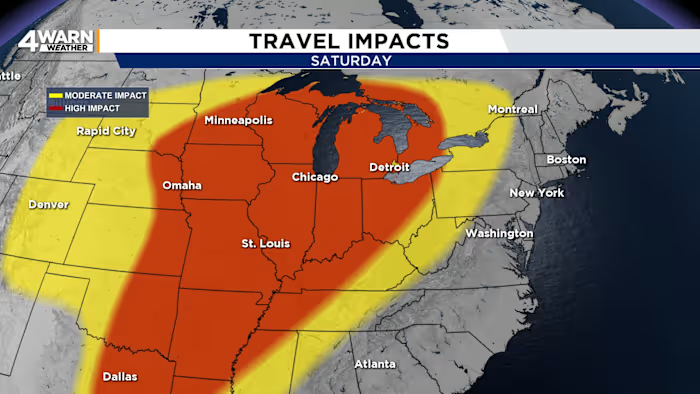
Air travelers should prepare for delays. The snow in Metro Detroit will be part of a larger system stretching across the Midwest. Major hubs such as Chicago, Minneapolis, Cleveland, and Indianapolis — all of which are common connection points — are also likely to experience weather-related delays or cancellations associated with this system.
Holiday shoppers heading out Saturday night or early Sunday should plan for slower travel times and allow extra time to reach their destinations.
National Outlook: Storm system affecting multiple regions
The same storm impacting Michigan will be part of a larger weather pattern affecting much of the central and eastern United States. The strongest winter impacts will extend from the Plains into the Midwest and Great Lakes, but areas in the Northeast may also see accumulating snow or icy conditions by Sunday night into Monday. This broad footprint increases the likelihood of delays across the national air travel network.
More on why exact snowfall totals will need adjustment
Several factors limit the precision of snowfall forecasts at this stage, even with high confidence in widespread accumulation:
-
Temperatures near freezing may cause initial snow to melt on contact.
-
A narrow zone of rain or mixed precipitation could briefly cut into totals, especially south of Detroit.
-
The speed of the storm may influence how long the heaviest snow lingers.
-
Snow-to-liquid ratios need to be determined, but wetter snow would mean more compact or denser snow.
The 4Warn Weather team will refine the snowfall map as the colder air pattern becomes more clearly defined and the exact track of the low-pressure system becomes known.
What to expect overall
-
Friday morning: Wind chills in the single digits and teens, and flurries and lake-effect snow in the Thumb.
-
Saturday afternoon: Snow develops and travel begins to slow.
-
Saturday night: Heaviest snow.
-
Sunday morning: Snow tapers, but risk of slick roads continues. Colder and windier. Snow totals reach 2–5 inches for most areas and localized 6-inch totals.
-
Sunday afternoon: Gradual improvement but still chilly.
Southeast Michigan is preparing for a winter storm that will create significant travel impacts during a busy weekend. From bitter cold early Friday to steady snow Saturday night and lingering slick roads Sunday morning, the next several days will demand caution and patience. People should plan for slower travel, monitor forecast updates, and allow for flexibility in weekend plans.
Share your holiday and weather photos with Local 4 at MIPics.
Copyright 2025 by WDIV ClickOnDetroit – All rights reserved.