

Why is the south of England under a heat dome?published at 13:23 BST
Sam Fraser
Weather presenter, BBC South Today
If you’re wondering why this week’s heatwave feels unusual,
that’s because it is!
A powerful high-pressure system has planted itself firmly
over southern England, and it’s reluctant to move.
In simple terms, that high pressure
acts like a giant atmospheric lid – literally a heat dome – it suppresses cloud
formation, pushes warm air downward, and shuts out any cooling breeze.
When
that high sits stubbornly in place for days at a time, as it has this week,
there’s simply nothing to interrupt the heat building beneath it.
The real story lies in where this air has come from. A
strong southerly flow ahead of the high is drawing warmth all the way from the
Iberian Peninsula and North Africa.
By the time that air mass reaches us here in the south
of the UK, it has already spent days travelling over sun-baked continental
land, arriving dry and extremely warm.
Crucially, as this intense heat bakes
the UK landscape, it is trapping moisture near the ground creating humidity
that’s contributing to the unusually high heat index.
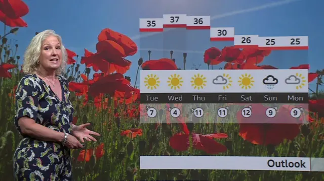
The high-pressure system is forecast to nudge eastward by the weekend, allowing a fresher Atlantic flow to filter back in from the west.
Temperatures should ease noticeably by Saturday, though that transition may trigger some heavy, thundery showers before cooler air fully establishes itself.
For the time being, stay out of the sun as far as you can, stay hydrated and keep your curtains closed!