(Image credit: Tracey Croke)
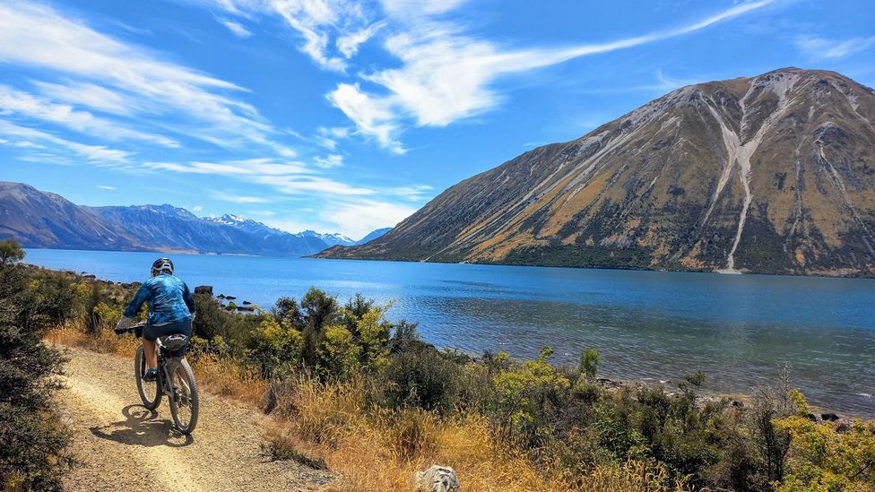
The country’s longest continuous bike trail – the Alps to Ocean – takes travellers on a 315km journey into the seismic-shifting saga of Zealandia, Earth’s “lost” continent.
A
A young and restless country in Earth’s development story, New Zealand lies along an exceptionally fractious crack in the planet’s crust. Tectonically speaking, the landmass has been through a lot of upheaval in the (relatively short) 83 million years since it split from the Gondwana supercontinent to be on its own plate. And now I am with my husband and two friends on New Zealand’s longest continuous bike trail – the Alps to Ocean (A2O) – that will take us through the heart of this seismic-shifting saga.
“What you’re passing through on the Alps to Ocean trail is the story of Zealandia, the eighth continent of the world,” says geoscientist Sasha Morriss.
After Zealandia departed Gondwana for Pacific isolation, it sank then erupted, giving rise to the Southern Alps extending across much of the nation’s South Island and some of New Zealand’s most remarkable landscapes. Its fossil-rich seabed also surfaced, revealing microscopic to megafauna skeletons that tell scientists about a disappeared sea and the severe weather patterns that followed to shape the country as we know it. A twist in the plot is that 94% of Zealandia remained “lost” underwater, hidden in plain sight, until satellite technology advanced and researchers officially mapped it 2017. “New Zealand is just the very top,” Morriss says.
The epic 315km A2O, one of the country’s 23 Ngā Haerenga Great Rides, starts in the foothills of the country’s highest peak, Aoraki/Mount Cook (3,724m). From here, it meanders through the Southern Alps’ broad, glacier-carved valleys into Waitaki Whitestone Geopark, established in 2023, which Morriss describes as a “vanished world” where dolphins with shark-like teeth once swam in a warm shallow sea. The trail finishes at Ōamaru, a town literally built from the ancient seabed we’ll ride on.
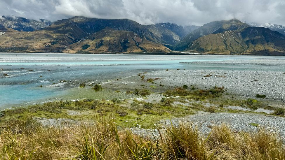
The 315km trail takes cyclists into the Waitaki Whitestone Geopark, which was formed under an ancient sea (Credit: Tracey Croke)
In parts, the A2O is so remote that at night the Milky Way can be seen in some of the clearest night skies in the world. However, isolation shouldn’t put anyone off: several companies offer guided trips, which include luggage transfers to prebooked accommodation (farmsteads, lake lodges and boutique B&Bs). A support vehicle tags along. But the good news is, with the number of e-bikes now available, it’s unlikely riders will need it.
Set Out
Set Out is a BBC Travel series that celebrates slow, self-propelled travel and invites readers to get outside and reconnect with the world in a safe and sustainable way.
Up until recently, the full A2O would only be tackled by very fit cyclists. However, e-bike supply chains have finally caught up from the surge in popularity during the pandemic and local adventure companies have invested in new fleets. The result is that the mainly smooth and predominantly undulating Alps 2 Ocean has opened up to a significantly wider demographic.
As adept cyclists with limited time, we’ve opted for regular mountain bikes on a customisable five-day self-guided trip. The raw newness of New Zealand hits us on our first easy 7km roll down a gravelly path to the Tasman Valley, where our ride is wonderfully interrupted by alpine headwaters that we need to cross by helicopter. Earth’s forces only heaved up the Southern Alps – one of the world’s fastest-growing and eroding ranges – within the last five million years. Streams of scree slide down near-vertical slopes. The sheer volume forces glacial meltwater into striking braids of milky blue and bright grey that fan out across the vast valley floor, which will eventually become the mighty 200km Waitaki River.
While the icy knife edges of Aoraki/Mount Cook glare from above, a five-minute flight – with our mountain bikes swinging precariously in a cage underneath – gives us a bird’s eye view of the sparkling phenomena. Deposited deeper into isolation, we jump back on our bikes and ride a colossal, vibrant, flat grassy plain to Lake Pūkaki. At 178sq km, it’s the largest in a chain of brilliant turquoise glacial lakes to come. The juvenile spine of the Southern Alps keeps us company until we reach our cosy motel in the subalpine town of Twizel to wrap up our first (77km) day.

Until recently, the full A2O could only be tackled by very fit cyclists (Credit: Tracey Croke)
The next morning, we enter the 7,200 sq km Whitestone Waitaki Geopark – Australasia’s only Unesco Global Geopark – where we spend a good chunk of the day exploring its squiggly foreshore, popping in and out of sheltered bays where we skim stones – perhaps a microfossil or two – across serene waters. It’s easy to imagine the killer dolphins that lurked long before glaciers shunted, sculpting its ragged mountain surrounds. These pre-human shores were also a penguin paradise. According to studies of fossilised bones found in the geopark, a giant, 154kg penguin (Kumimanu fordycei) once shuffled around here, three times heavier than today’s largest species, the emperor penguin.
PLAN YOUR TRIP
The ride is supported by several companies who provide everything you need including mountain bikes/e-bikes and luggage transfers. Book with Adventure South NZ (guided), Escape by Cycle (guided), Cycle Journeys (guided and self-guided) or Trail Journeys (self-guided). Both guided and self-guided tours include bikes and a map with points of interest along the waymarked route. Summer and autumn (December to May) are ideal times to ride the trail.
The following day is as tough as the A2O gets, with a steady 300m climb over a generous 5km through a shady forest to the journey’s 900m highpoint at Tarnbrae. I’m several hundred years too late to spot a now-extinct Haast’s eagle, but I can imagine this giant bird – the largest eagle to ever have existed, with a 3m wingspan and feet and claws as big as a modern day tiger’s – gliding over the infinite prairie-like Mackenzie Basin. There’s a big buzz in our plunge down a flowy trail into throngs of golden tussocks, where the huge eagle would’ve sank its claws into flightless prey, namely the ostrich-like moa bird that weighed as much as 250kg.
At this point, we think we’ve nailed the day, until we enter the hair-raising Sailors Cutting Scenic Reserve to ride a gusty 13km loose, narrow trail cut into the side of a sheer gorge that’s so raw and exposed, I feel like I’ve been thrown back to Gondwanan times when plesiosaurs – ferocious long-necked marine dinosaurs – patrolled the shores. Prior to the A2O, seeing this part of the gorge was only possible by boat. By the time we get to our B&B in the tiny town of Otematata, we’ve clocked an exhausting 80kms that I’d move mountains to do again
More like this:
• The Véloroute Gourmande: Canada’s delectable 235km food trail
• A new chance to hike Europe’s ancient salt route
• Europe’s ‘underdog leader’ in slow-travel biking
The next day, on the 75km ride to what feels like bustling Duntroon (population: 110), people play more of a part as the trail nods to cultural history and human development. We ride over the Waitaki dam and hydro-electric power station, built during the Great Depression, when locals (mostly) excavated half a million cubic metres (200 Olympic-sized swimming pools) using only picks and shovels. The ramshackle ruins of a hotel that served explorers in goldrush times is our rest stop and we sleep like logs in a lovingly restored 1908 farmstead.
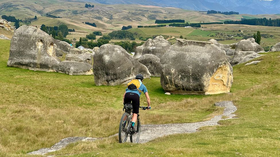
Elephant Rocks are a surreal collection of grey boulders that formed when the seabed lifted and fractured (Credit: Tracey Croke)
The lion’s share of geological action is packed into our fifth and final day. Here, the A2O overlaps with the 34km (drivable) Vanished World Trail where visitors can find the most accessible geological features, such as the oddly named Brewery Hole – a cavernous sinkhole in the ancient seabed from which “bubbles forth a [underground] stream of pure sparkling water”, according to an article from 1877 in the North Otago Times. It’s also an excellent demonstration of how acidic rainwater can perilously dissolve soft rock.
Vanished World Trail
This 34km scenic drive takes in accessible landforms, distinctive rocks, minerals and fossil sites in Waitaki Whitestone Geopark. It starts at the Vanished World Centre in Duntroon where you can learn about the region’s fossil finds and even dig out your own from a chunk of local Otekaike Limestone.
The nearby Valley of the Whales features a partially exposed baleen whale skeleton fossil, preserved in cliffs made from dead sea organisms that built up around 25 million years ago. A stone’s throw away, we get more deeply immersed in the vanished sea as we ride on a grassy paddock through a surreal collection of grey mammoth boulders known as Elephant Rocks, which were formed when the seabed lifted and fractured. While softer surrounding sediments disappeared with the sea, weathering got to work sanding rough edges. Bizarrely, the rocks – some as big as houses – lie in a (accessible) farmer’s field dotted with grazing sheep. Fans of The Chronicles of Narnia will recognise the scene (minus livestock) as Aslan’s camp.
In the end, the country’s largest fossil collection turns out to be Ōamaru, a grandiose Neoclassical port town built with rock quarried from its abundant limestone seabed surrounds. After all, limestone is mostly billions of decayed ancient sea creatures that have been cemented together over millions of years. And rather like the lost continent of Zealandia, it’s been hidden in plain sight all along.
—
If you liked this story, sign up for The Essential List newsletter – a handpicked selection of features, videos and can’t-miss news, delivered to your inbox twice a week.
For more Travel stories from the BBC, follow us on Facebook, X and Instagram.
;


