
Winter is continuing to rear its ugly head this week across the Midwest and Northeast, courtesy of a potent storm that’s forecast to spread a nasty mix of ice and snow Wednesday and Thursday.

How airlines keep flights running smoothly during winter storms
What airlines do to prepare for winter weather and keep passengers safe
That pesky groundhog was right.
Winter is continuing to rear its ugly head this week across the Midwest and Northeast, courtesy of a potent storm that’s forecast to spread a nasty mix of ice and snow Wednesday and Thursday.
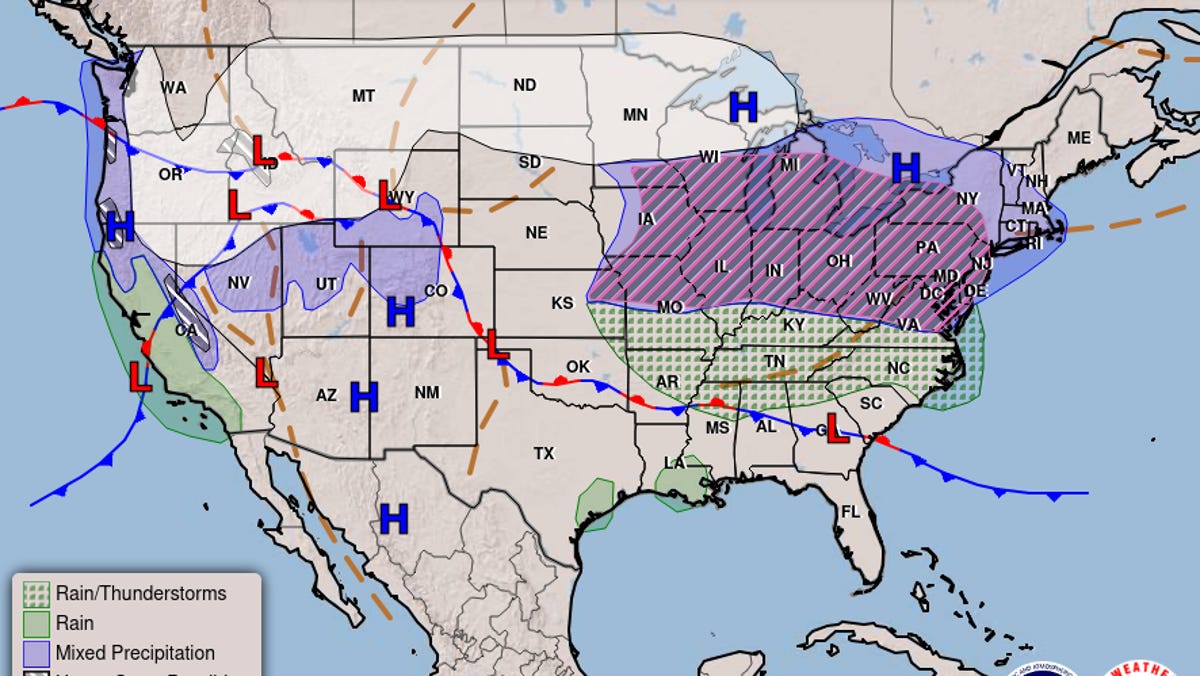
“The ingredients for a major ice storm are expected to be in place beginning Wednesday across a zone spanning from the Midwest to the Great Lakes,” AccuWeather meteorologist Brandon Buckingham said in a Monday e-mail to USA TODAY. He said the storm will continue in the Northeast on Thursday.
“A clash of warm, humid air and cold arctic air will result in a myriad of impactful weather for millions of Americans this week,” he said.
Freezing rain expected; Maryland and Pennsylvania could see the worst
The National Weather Service warned of a “widespread, impactful freezing rain event from the Midwest across the Lower Peninsula of Michigan into the Mid-Atlantic states Wednesday and into southern New England Thursday.”
Areas including Harrisburg, Scranton, State College and Williamsport in Pennsylvania, Binghamton in New York and Cumberland in Maryland face the greatest risk of dangerous ice accretion, AccuWeather said.
The highest ice storm potential (with 1/4 inch or greater ice accretion) “is expected from western Maryland northward into the Laurel Highlands of Pennsylvania, where scattered power outages and tree damage is most likely,” the weather service said.
A much larger area extending as far south and east as the I-95 corridor from Washington to Baltimore, Philadelphia, New York and Boston, is expected to see a briefer period of icing, AccuWeather said.
What the weather means for you: Sign up for USA TODAY’s Climate Point newsletter.
‘Travel could be nearly impossible’
In a winter storm watch issued for Wednesday, the weather service said “roads, and especially bridges and overpasses, will likely become slick and hazardous. Power outages and tree damage are likely due to the ice. Travel could be nearly impossible. The hazardous conditions could impact the Wednesday evening and Thursday morning commutes.”
AccuWeather Chief Meteorologist Jonathan Porter warned of the perils from ice. “Ice storms are incredibly dangerous. A light glaze of ice can create treacherous driving conditions on bridges, highways and ramps in a matter of seconds. A half inch of ice accumulation can add 500 pounds of extra weight or more to power lines. Tree branches coated in ice can snap and fall on power lines.
“Families and businesses should be prepared for the risk of extended power outages that could leave them without heat and utilities for several days after the storm,” Porter said.
Why ice and not snow?
Because there will be a “warm air sandwich,” with cold air as the slices of bread, as shown in the graphic below.
Freezing rain occurs if that warm air layer in the atmosphere is thick enough, with only a shallow layer of below-freezing air at the surface, the National Weather Service said. Precipitation begins as either rain and/or snow but becomes all rain in that warm layer.
The water then freezes on contact with the surface, creating a coating of ice on whatever the raindrops contact.
Upon hitting the ground or objects such as bridges and vehicles, the rain freezes on contact. Some of the most disastrous winter weather storms are due primarily to freezing rain.
Snow also likely in some areas
Though not as dangerous as the ice threat, snow will also be a factor with this system in some areas.
“We don’t anticipate heavy snowfall totals from this system in most areas, but at least a coating to a few inches is forecast from North Dakota and central and northern Minnesota to upstate New York and northern New England,” said Weather.com meteorologist Chris Dolce in an online forecast.
“Any accumulating snow near and west of Interstate 95 from New York to Boston should be light before changing to a wintry mix and rain,” he said.
More storms will be inbound
This midweek storm is only the first in a series of winter storms that are on the way for the northern U.S.
AccuWeather lead long-range expert Paul Pastelok said a second winter storm will follow this midweek storm, and snow and ice could impact some of the same areas starting Friday through the weekend.
Then, “a third storm is possible early next week, with the potential of colder air and more moisture that could bring snow and icy impacts to a larger area,” he said.